Professor
Raimundo Bambó Naya [ES]
In collaborazione con il gruppo di ricerca Architettura e Paesaggio del dipartimento di Culture del Progetto.
EN //
Keywords
Piave, Heritage-landscape, rivers, cultural resources, safety measures, production, use, development
The workshop program will focus the research on the topic of “river landscapes”, with particular attention to certain territorial situations of the Veneto’s hydrographic system. The “river landscapes” – where infrastructure pressures and settlements in potential conflict with the environmental hydro-geological and vegetation data usually converge, and in which obsolescent architectural and infrastructural heritage is frequently found – are a very representative field to experience design processes in line with the objectives described above.
Rivers themselves represent a natural and geographical heritage of crucial importance in the genesis of local settlements, as well as in the shaping of the character of the rural and urban landscape: a heritage that however over the last century has met processes of exploitation and neglect that trigger worrisome phenomena of marginalization and decay.
Theme
The river landscape and its use through the creation of a park, configured in relation to the enhancement of its cultural and environmental resources, the “technical form” and the various natural areas.
Site
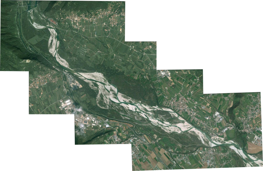
The project will be developed in the middle part of the Piave river between the bridge north of the Fener dam (SP32) and the bridge between Covolo and Bigolino (SP2), affecting the territories of Pederobba and Valdobbiadene. This part of the river landscape is characterized by a dam with a hydroelectric power plant, located upstream; and on the right bank, in a rather narrow strip, by the Brentella channel, alongside the railway line and the Feltrina road SR348. Small production areas are located among these infrastructural lines, but also Sic and Zps zones, as Pederobba’s oasis LIPU Garzaia and other areas of outstanding natural value, all landlocked by a large cement plant and by the edge of an extensive industrial area to the south. The context on the left bank has a lower infrastructural presence near the river, whose margins are outlined by wooded areas interrupted only in two points: on the north at the confluence of SP26-SP28 near the town of Valdobbiadene, and on the south near the town of Bigolino.
Aims
• To insert recreational paths for the enjoyment of the landscape, capable of recognizing the places of the river and its technical form as heritage and the structure that provides identity to the urban settlements flanking the river.
• To improve accessibility to the riverbank areas, in relation to residential areas and possible new productive and touristic uses.
• To organize resources and potentialities for the definition of an eco-productive river park, where different uses can find a sustainable integration and contribute to the redevelopment of the region through the enhancement of the landscape.
IT //
Parole chiave
Patrimonio-paesaggio, patrimonio in produzione, fiumi, risorse culturali, messa in sicurezza, produzione, fruizione, valorizzazione
La proposta per il workshop 2015 intende concentrare la ricerca sul tema dei “paesaggi di fiume”, con particolare attenzione ad alcune situazioni territoriali del sistema idrografico veneto. I “paesaggi di fiume” – su cui spesso si concentrano pressioni infrastrutturali e insediative in potenziale conflitto con i dati ambientali idro-geologici e vegetazionali e in cui spesso si ritrovano patrimoni architettonici o infrastrutturali in disuso o in obsolescenza – appaiono un campione molto rappresentativo per sperimentare processi progettuali in linea con gli obiettivi descritti in precedenza.
I fiumi stessi rappresentano un patrimonio naturale e geografico di importanza decisiva nella genesi degli insediamenti territoriali, così come nella conformazione dei caratteri del paesaggio agrario ed urbano: un patrimonio che ha tuttavia incontrato nel corso dell’ultimo secolo processi di sfruttamento e di abbandono tali da innescare preoccupanti fenomeni di emarginazione e decadenza.
Tema
Il paesaggio del fiume e la sua fruizione attraverso la realizzazione di un parco da configurare in rapporto alla valorizzazione delle risorse culturali e ambientali, della “forma tecnica” e dei diversi ambiti naturalistici.
Luogo
Il progetto si svilupperà nel tratto medio del fiume Piave compreso tra il ponte a nord della presa di Fener (SP32) e il ponte tra Covolo e Bigolino (SP2), che va a interessare i territori dei comuni di Pederobba e Valdobbiadene. Questa parte del paesaggio fluviale è caratterizzata, a monte, da una diga con la centrale idroelettrica; sulla riva destra, in una fascia piuttosto stretta, dal canale Brentella, cui si affiancano la linea ferroviaria e la strada SR348 Feltrina. Tra queste linee infrastrutturali si collocano piccole aree produttive come delle peschiere, ma anche zone Sic e Zps, come l’oasi LIPU Garzaia di Pederobba e altri ambiti di notevole pregio naturalistico interclusi da un grande cementificio e più a sud dai margini di una estesa zona industriale. Sulla riva sinistra il contesto appare meno infrastrutturato in prossimità del fiume, i cui margini sono delineati da aree boscate che si aprono a nord solo in corrispondenza della confluenza SP26 -SP28, presso l’abitato di Valdobbiadene, e a sud con il centro urbano di Bigolino.
Obiettivi
• Inserire percorsi di fruizione del paesaggio che riescano a riconoscere i luoghi del fiume e la sua forma tecnica come patrimonio e struttura identitaria dei nuclei urbani che si affiancano al corso d’acqua.
• Migliorare l’accessibilità alle aree di fascia fluviale, in rapporto ai centri abitati e a nuovi possibili usi produttivi e turistici.
• Mettere a sistema risorse e potenzialità per la definizione di un parco fluviale eco-produttivo, dove i diversi usi possano trovare una integrazione sostenibile e contribuire alla riqualificazione del territorio attraverso la valorizzazione del paesaggio.


Leave a Reply